
Martín Jacques Coper, Principal Researcher of the Center for Climate Science and Resilience CR2, and Christian Segura, CR2 Data Analyst
- Recent research has identified two atmospheric precursors that can help anticipate the occurrence of heat waves in the central-southern zone of Chile.
- When both factors are observed in sequence, a heat wave may develop approximately two weeks later in central-southern Chile.
- Currently, these two precursors are active, so a heat wave is likely to occur in central-southern Chile in late January and early February 2024.
We are in the second half of January 2024, and summer is in full swing. In this context, heat waves are one of the extreme weather events that garner the most interest, partly due to their potential impacts.
A year ago, we conducted an analysis that shared information on their definition, some interannual variability, and long-term trends. Moreover, we have complemented and updated this information in a recent report highlighting some aspects of González-Reyes et al. (2023).
However, currently, under El Niño conditions—which alone do not imply warmer conditions in central-southern Chile, unlike the northern coastal region of the country—and as indicated by the Meteorological Directorate of Chile (DMC), no heat waves have been registered in the last 90 days in this macro-region (Figure 1).
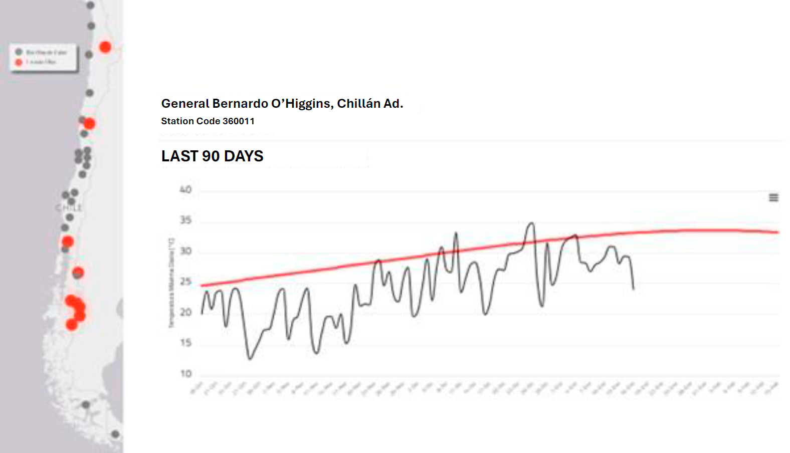
Figure 1. (left) The left panel is a map of Meteorological Directorate of Chile (DMC) stations; those that register heat waves between October 18, 2023, and January 16, 2024, are highlighted in red. The right panel shows the daily maximum temperature recorded at the General Bernardo O’Higgins station in Chillán, in the October 2023 – January 2024 period (black curve); the red curve represents the climatological threshold above which heat waves are defined if the maximum temperature persists above it for at least three consecutive days. As shown, no heat waves have been recorded at this station during the last 90 days, defined as periods with maximum temperature above the threshold for at least three consecutive days. Source: DMC. https://climatologia.meteochile.gob.cl/application/mensual/olasDeCalorRecientes/360011/2024/01/16
However, the fact that no heat waves have been recorded in recent months does not imply that the 2023-2024 summer will end without them. Weather forecasts announce high temperatures for this area in the coming days, and we will likely record the first heat waves of the year. Remember that to form a heat wave, the maximum temperature must exceed an intensity threshold and persist for at least three days. Precisely, it is during the next few weeks (between late January and early February) when the highest maximum temperatures of the year are expected; therefore, this period also corresponds to the highest threshold values of the entire year, as can be seen by observing the red curve in Figure 1.
As we shared in Figure 1 of a previous CR2 Analysis, heat waves result from a very particular meteorological configuration that can be summarised as an atmospheric blocking pattern that promotes clear skies and high solar radiation (Jacques-Coper et al., 2021; Demortier et al., 2021). The ability to anticipate both types of conditions over a time frame greater than a week is essential to mitigate potential related impacts. This is particularly sensitive in the case of wildfires, where one factor is extreme meteorology in a changing climate regime.
To move towards heat wave forecasts in this time range, our research (Jacques-Coper et al., 2021) has detected two potential precursors of these events through atmospheric teleconnections. The first is a dipole of atmospheric circulation at mid-levels over the southern Indian Ocean. The standardised extra-tropical index (sETI) is used to monitor this dipole’s occurrence. When sETI exceeds a value of 1, it means this dipole is active, which can cause extreme heat in central-southern Chile in a timeframe close to two weeks. This occurred, for example, on December 11, 2023, when sETI exceeded the value of 1, and two weeks later, there was a hot Christmas on the 25th, with temperatures exceeding 35°C.
The second precursor refers to the activity of the Madden-Julian Oscillation (MJO), the primary modulator of intraseasonal variability (i.e., in the range of a few weeks) in the tropics, influencing the meteorology of the subtropical and extratropical zones. Specifically, we identified the active phase 4 of the MJO as the second precursor of heat waves in central-southern Chile. This active phase 4 situation means intense convection (i.e., regional ascent of air and formation of vertically developed clouds) occurs near Indonesia.
Both sETI greater than one and the active phase 4 of the MJO is associated with the propagation of atmospheric waves relevant to the atmospheric configuration that triggers heat waves in the central-southern zone of Chile. With this information, it is necessary to inquire about the current values that both precursors present. To monitor such values, we have implemented a heat wave precursor platform. As shown in Figure 2, sETI has exceeded the threshold of 1, indicating the presence of the southern Indian Ocean dipole. This means the first potential heat wave precursor is active (note that sETI also approached one on January 7).
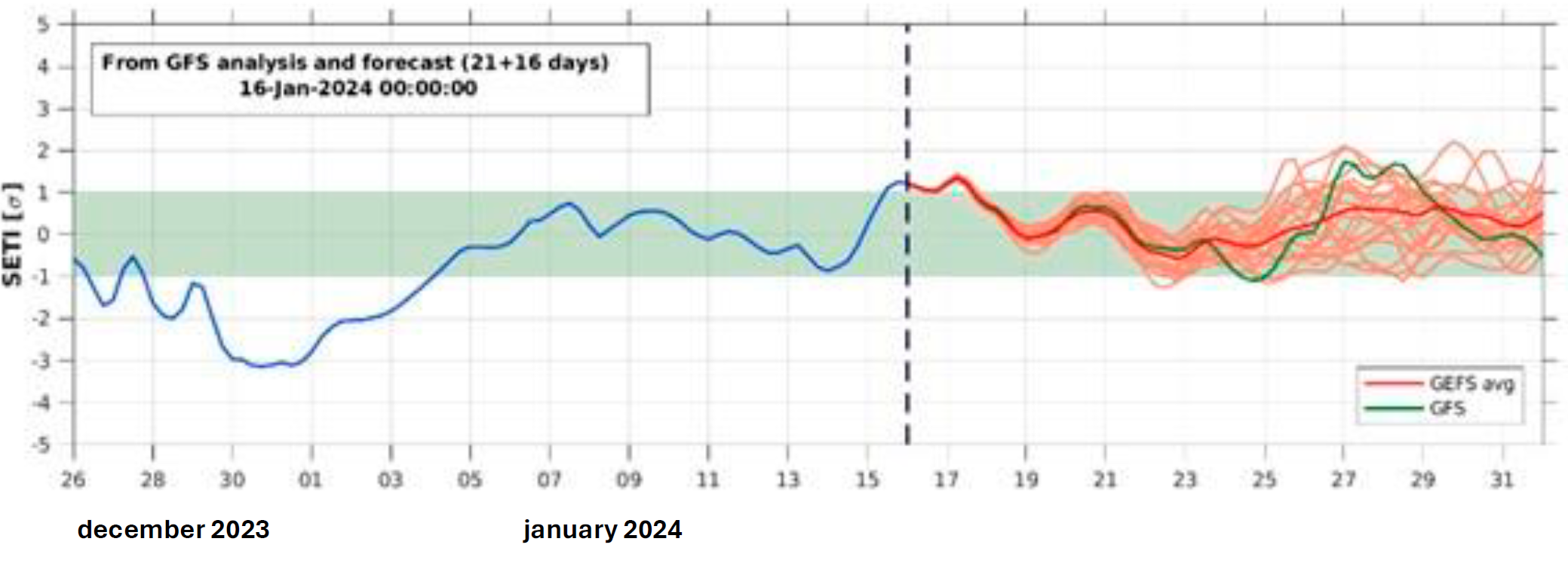
Figure 2. Standardised extra-tropical index (sETI), representing mid-level atmospheric circulation anomalies over the southern Indian Ocean. The vertical segmented line separates the analyses of the model towards the past and the probabilistic forecasts towards the future for a 16-day horizon, using the 20-member GEFS “ensemble” (orange curves) that define an average curve (red curve), as well as an operational run at higher spatial resolution (green curve)—source: olasdecalor.cr2.cl.
As for the MJO, as shown in Figure 3, we are currently observing the active phase 4. In other words, the second potential heat wave precursor is also active. Furthermore, the MJO is expected to evolve towards its active phase 6 by late January, which is favourable for the occurrence of heat waves in central-southern Chile (Jacques-Coper et al., 2021).
Together, both precursors indicate an increase in temperatures in central-southern Chile that could evolve into a heat wave for the January-February 2024 transition, which, as we mentioned earlier, is the warmest period of the year. If we recall, it is no coincidence that in 2017 and 2023, devastating summers due to mega wildfires exceeded the 40°C threshold during that period.
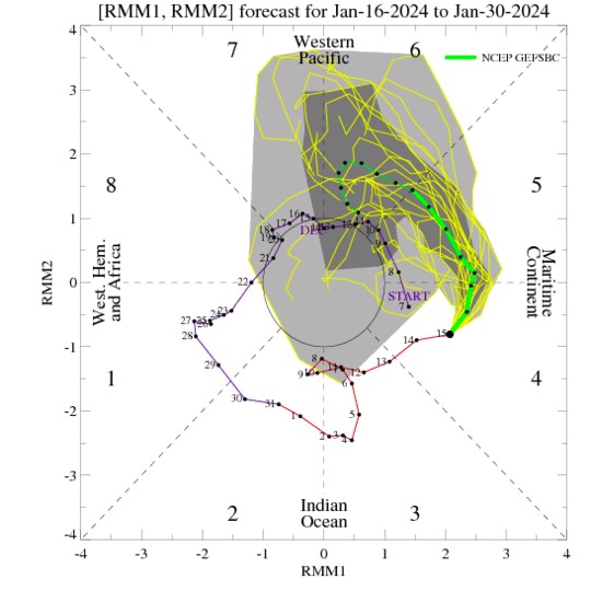
Figure 3. Diagram showing the progression of the Madden-Julian Oscillation (MJO) through each of its phases over the last forty days (December 7, 2023, to January 15, 2024). The purple line corresponds to the MJO in December, and the red line to January (each with the respective days of the month). From January 15, the yellow curve represents a forecast of the evolution of the MJO, and the green line is an average. It is seen that the MJO is already in phase 4 and could advance to phase 6, which creates conditions for heat in the central-southern zone of Chile. Source: https://www.cpc.ncep.noaa.gov/products/precip/CWlink/MJO/foregfs.shtml
Heat Waves and Red Tide
In the case of southern Chile (approximately between 38° and 45°S), the El Niño condition is related to summers that tend to be dry. Furthermore, another seasonal-scale climatic factor is relevant in this region: the Southern Annular Mode (SAM), which modulates the north-south atmospheric pressure gradient between subpolar and polar regions (see this CR2 Analysis). The positive phase of SAM—which has been observed during the last month—also generates below-normal precipitation in the described region.
The current situation of the superposition of El Niño and the positive phase of SAM has previously been identified as a relevant forcing of harmful algal blooms (traditionally known as “red tide”) in the Los Lagos region, as was the case in 2016 (León-Muñoz et al., 2018; Garreaud, 2018). Transcending the seasonal scale towards shorter periods, where meteorology becomes relevant, recent research shows the connection between conditions of extreme and persistent heat with events of high phytoplankton biomass in the Inner Sea of Chiloé (Jacques-Coper et al., 2023).
Indeed, as shown in Figure 4, exceptionally high levels of summer chlorophyll-a and fluorescence detected via satellite (panels a and b) are preceded and accompanied by positive anomalies of solar radiation (panel c), an increase in sea surface temperature (panel d), and a reduction in the upper layer of the ocean (panel e), all of which represents greater stratification of the upper levels of the water column. This period of atmospheric stability may eventually include light and transient precipitation. Although these events do not necessarily represent harmful algal blooms, both can be related, as has occurred on previous occasions.
Extreme heat events in central and southern Chile constitute first-order meteorological threats during the summer. This warrants that we continue to monitor the atmosphere and its teleconnections, aiming to communicate potentially relevant information to better prepare for and mitigate possible impacts.
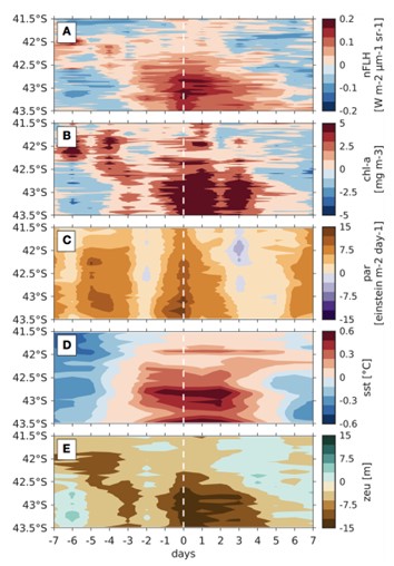
Figure 4. Events of high phytoplankton biomass presence along the Inner Sea of Chiloé (between 41.5° and 43.5°S). The white segmented line marks the beginning of the events. The figure spans 15 days (one week before and one week after such events). All variables are presented as anomalies, i.e., deviations from the average. The panels correspond to (A) fluorescence, (B) chlorophyll-a, (C) solar radiation, (D) sea surface temperature, and (E) depth of the photic layer (upper layer of the ocean where up to 1% of solar light penetrates). Source: Jacques-Coper et al., 2023
References
Demortier, A., Bozkurt, D., & Jacques-Coper, M. (2021). Identifying fundamental driving mechanisms of heat waves in central Chile. Climate Dynamics, 57(9), 2415-2432. https://doi.org/10.1007/s00382-021-05810-z
Garreaud, R. D. (2018). Record-breaking climate anomalies led to severe drought and environmental disruption in western Patagonia in 2016. Clim Res. 74, 217–229. doi: https://doi.org/10.3354/cr01505
González-Reyes, A., Jacques-Coper, M., Bravo, C., Rojas, M., Garreaud, R. (2023): Evolution of heataves in Chile since 1980, Weather and Climate Extremes, 41, 100588, https://doi.org/10.1016/j.wace.2023.100588
Jacques‐Coper, M., Veloso‐Aguila, D., Segura, C., & Valencia, A. (2021). Intraseasonal teleconnections leading to heat waves in central Chile. International Journal of Climatology, 41(9), 4712-4731. https://doi.org/10.1002/joc.7096
Jacques-Coper, M., Segura, C., de la Torre, M.B., Valdebenito, P., Vásquez, S.I., Narváez, D. (2023). Synoptic-to-intraseasonal atmospheric modulation of phytoplankton biomass in the Inner Sea of Chiloé, Northwest Patagonia (42.5º-43.5ºS, 72.5º-74ºW), Chile, Front. Mar. Sci. Sec. Coastal Ocean Processes, 10, https://doi.org/10.3389/fmars.2023.1160230
León-Muñoz, J., Urbina, M. A., Garreaud, R., and Iriarte, J. L. (2018). Hydroclimatic conditions trigger record harmful algal bloom in western Patagonia (summer 2016). Sci. Rep. 8 (1), 1–10. doi: https://doi.org/10.1038/s41598-018-19461-4
 Secures Its Continuity")

, an Endangered Species")