
By René Garreaud, (CR)2 director and DGF-U.Chile professor; Martín Jacques, (CR)2 researcher and DGEO-UdeC professor; and Aníbal Pauchard, IEB researcher and Forestry-UdeC professor.
The summers of 2017 and 2023 have revealed a new and devastating regime of forest fires in the south-central zone of Chile, in which a few events experience rapid and intense spread, burning hundreds of thousands of hectares (ha) in the first few days from ignition. The total burned area in each of the seasons exceeded 450,000 ha—nearly ten times the historical average—causing the unfortunate death of dozens of people, the destruction of residences and infrastructure, the deterioration of biodiversity, and significant losses in various productive sectors. In this analysis, we show that these megafires have coincided with extremely hot days (air temperatures above 40 °C) and very intense winds in the area, which, together with abundant and continuous fuel from vegetation and multiple sources of ignition, create a perfect recipe for generating serious socio-environmental catastrophes. These meteorological conditions are also unprecedented in the historical record, and their recurrence in recent years suggests a contribution of climate change to the establishment of this new regime of forest fires.
How it was before…
The recent history (1985-2015) of forest fires in Chile is characterized by several thousand events (5,000 on average) per season, concentrated between November and March, with the majority occurring in the regions of Valparaíso and Los Ríos. The burned area covers a wide range, ranging from fires of less than one hectare (ha) to large events (over 200 ha) and reaching thousands and tens of thousands of hectares (González et al., 2020). By season, the burned area fluctuates between 10,000 and 100,000 ha, with an average of around 50,000.
The spatial distribution of fires is determined by the initial source of ignition, the direction and extension of propagation, and the land use, which determines the amount and type of fuel, including forests and forest plantations. It is essential to consider that the origin of forest fires can occur outside the forest, such as on the edge of roads, rural properties, or even in urban areas adjacent to forest territories, but they can quickly take on a forest character when they spread towards forests and forest plantations where there is a large amount of fuel. The variations of the burned area between one season and another are modulated by the climatic conditions that occur before and during the fire season, especially temperature, humidity, and precipitation (Urrutia-Jalabert et al., 2018).
A new regime
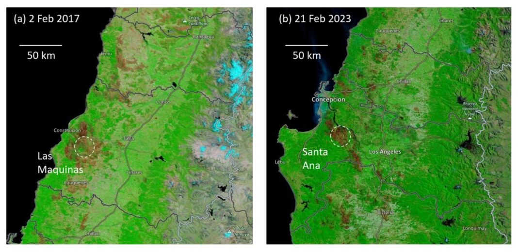
The mega-drought in central Chile, which corresponds to the uninterrupted period of deficient rainfall that began in 2010 and continues to the present, has altered the historical fire regime, increasing the burned area, the number of events outside of summer, and the simultaneity of events (González et al., 2018). Within this period of change, the 2016-2017 season is unprecedented. Although the number of fires was relatively below average, the total burned area reached 560,000 ha, equivalent to ten times the historical average. Indeed, such a record of affected area was mainly due to the occurrence of four mega-fires (more than 50,000 ha burned in each of them) in the Maule and O’Higgins regions during the second half of January 2017. Among them, the event that began in Las Máquinas (Maule Region) corresponds to the largest recorded in Chile, with more than 160,000 ha burned (Figure 2). These mega-fires were characterized by their extreme heat intensity and rapid spread, earning them the term “fire storms” (Bowman et al., 2018) or “sixth generation fires” (CONAF 2018).
After 2016-2017, the following fire seasons were within historical ranges for the number of events and area burned, until the current season (2022-2023) arrived. Several large fires in December and January, including a dramatic event on the outskirts of Viña del Mar the day before Christmas, brought the total burned area to around 100,000 ha. Then, at the beginning of February, several fires were generated in the Ñuble, Biobío and Araucanía regions, which reached the category of mega-fires due to their extensive duration, intensity and burned area. Among these events, the one in Santa Ana, commune of Santa Juana, stands out, which consumed more than 120,000 ha (Figure 2); a significant portion of the total was burned in the first three days of development and could only be controlled several weeks later.
The most dramatic impact of this season, especially the fires of February 2023, was the 25 fatalities. Added to this were the more than 450,000 ha consumed (eight times the historical average), producing a socio-environmental and economic cost, particularly in the forestry, agricultural and tourism sectors, which still needs to be quantified, but will undoubtedly be enormous. It will also be necessary to evaluate carbon dioxide emissions into the atmosphere and their impact on human health due to poor air quality. In fact, the levels of particulate matter remained in the emergency range for several days, in locations near and far from the fires.
Extreme weather
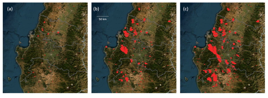
Extreme weather played a key role in these catastrophic events: an extreme warm event in the south-central zone, strong Puelche wind (from the east) in the foothills, and intense south wind in the coastal zone. Wind patterns are crucial in determining the progress of fires. For example, the explosive spread of the fires on February 3 and 4, 2023, occurred in a northeasterly direction, precisely due to the intense prevailing winds in the area during those days (Figure 4).
During the first days of February 2023, temperatures (and probably the wind) were extreme, with values above 40 °C in various stations in Ñuble, Biobío, and Araucanía. Using historical statistics, these values occur –on average– once a century, although we will see that the statistics are changing. A similar situation, with maximum temperatures above 40 °C in a large area of Maule, coincided with the most aggressive stage of the Las Máquinas mega-fire between January 25 and 26, 2017.
Thus, although the sample is limited, we can suggest that the mega-fires that are occurring in this new fire regime in central Chile are associated with extreme weather conditions. However, in the case of Chile, practically all fires begin with an ignition caused by human action, whether accidental or intentional. Under average conditions or even during an “ordinary” heat wave (let’s say an event of maximum temperatures around 35 °C in central Chile), it is expected that the fires will spread, and some may even become magnitude events. However, the events of January 2017 and February 2023 suggest that those ignitions that occur on days with temperatures above 40 °C can become mega-fires that consume hundreds of thousands of hectares in a few days, are very difficult to control, and trigger a socio-environmental catastrophe. In simple terms, extreme heat waves and high winds allow fire spread to be explosive, turning from “normal” wildfires to true “firestorms”.
Looking forward
During the past seven years, two record seasons in terms of burned area and three summers with extreme temperature events have occurred in central-southern Chile. It is noteworthy that no mega-fire was recorded in the summer of 2019, despite the occurrence of an extreme event (greater than 40 °C) in the center-south zone. This highlights that extreme weather in Chile provides favorable conditions for the violent propagation of a fire, but not its ignition. Fires would not occur without human ignition and a conducive landscape.
On the other hand, the occurrence of extreme temperature events in the central zone is unprecedented in recent history. In fact, observing three of them in seven consecutive years by mere coincidence is highly unlikely, suggesting an alteration in their frequency distribution due to ongoing climate change. The positive trend of the maximum temperature in the Central Valley of south-central Chile plays an important role in this phenomenon. A formal statistical attribution and physical explanation of how these events are associated with climate change is currently under development.
In short, we are witnessing a new regime of forest fires in south-central Chile, and projections of a drier and warmer climate in the coming decades will only exacerbate this issue. Studying the factors that contribute to these events can help inform well-informed decisions that promote mitigation in the future. Understanding aspects associated with extreme weather may improve the prediction of the conditions that favor the development of mega-fires, especially considering that firefighting capacity in the initial phase of each event is essential. While it is impossible to modify the climate, generating mechanisms to mitigate its impact is possible. In principle, this should include: (a) early warning systems for highly risky meteorological events, (b) proper management of vegetation and vegetable fuel in the territory, not only around populated areas but throughout the rural-forest landscape, and (c) reduction of sources of human ignition in the landscape, whether for accidental or intentional reasons.
References
Bowman, D. M., Moreira-Muñoz, A., Kolden, C. A., Chávez, R. O., Muñoz, A. A., Salinas, F., González-Reyes, Á., Rocco, R., De La Barrera, F., Williamson, G., Borchers, N., Cifuentes, L., Abatzoglou, J., & Johnston, F. H. (2019). Human–environmental drivers and impacts of the globally extreme 2017 Chilean fires. Ambio, 48, 350-362.
CONAF. (2018). Tormenta de fuego en Chile. Ministerio de Agricultura. https://www.conaf.cl/incendios-forestales/tormenta-de-fuego-en-chile/
González, M. E., Gómez‐González, S., Lara, A., Garreaud, R., & Díaz‐Hormazábal, I. (2018). The 2010–2015 Megadrought and its influence on the fire regime in central and south‐central Chile. Ecosphere, 9(8), e02300.
González, M.E., Sapiains, R., Gómez-González, S., Garreaud, R., Miranda, A., Galleguillos, M., Jacques, M., Pauchard, A., Hoyos, J., Cordero, L., Vásquez, F., Lara, A., Aldunce, P., Delgado, V., Arriagada, Ugarte, A.M., Sepúlveda, A., Farías, L., García, R., Rondanelli, R.,J., Ponce, R.,Vargas, F., Rojas, M., Boisier, J.P., C., Carrasco, Little, C., Osses, M., Zamorano, C., Díaz-Hormazábal, I., Ceballos, A., Guerra, E., Moncada, M., Castillo, I . (2020). Incendios forestales en Chile: causas, impactos y resiliencia. Centro de Ciencia del Clima y la Resiliencia (CR)2, (ANID/FONDAP/15110009), 84 pp. Available in https://www.cr2.cl/incendios/ (English version: https://www.cr2.cl/eng/forest-fires-in-chile-causes-impacts-and-resilience/)
Urrutia‐Jalabert, R., González, M. E., González‐Reyes, Á., Lara, A., & Garreaud, R. (2018). Climate variability and forest fires in central and south‐central Chile. Ecosphere, 9(4), e02171.
 Secures Its Continuity")

, an Endangered Species")