

René Garreaud, Deputy Director, Center for Climate and Resilience Research (CR)2; Carlos Zamorano, adjunct investigator (CR)2; Mauro González, associate investigator (CR)2; Antonio Lara, principal investigator (CR)2; and Martín Jacques, principal investigator (CR)2.
The extreme climatic conditions that were forecast at the beginning of summer, coupled with the extensive forestry plantations in parts of south-central Chile, raised the threat of fire to catastrophic proportions. In early autumn, we now have the perspective to enable us to identify lessons learned and challenges to come.
Historically, the maximum summer temperature for south-central Chile has been positively correlated to burned area, and this is the case between the regions of Valparaíso and Araucanía (Urrutia-Jalabert et al. 2018; González et al. 2018). This correlation is summarized in Figure 1, in which each symbol corresponds to an annual fire season in the 2000 to 2020 period, according to the maximum temperature index (seasonal averages at Quinta Normal, Curicó, Chillán, and Temuco) and total area burned between these regions. Although the correlation is significant, summer seasons with similar temperatures can display a high dispersion of fire-affected areas, as other factors also come into play in the occurrence and propagation of these fires. One of them is the cumulative precipitation in the months leading up to the fire season, which regulates the moisture content in the soil and hydric stress experienced by the vegetation (Urrutia-Jalabert et al. 2018).
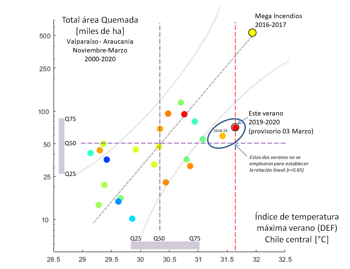 Figure 1: Climate-fire relationship. Each circle corresponds to one fire season in the 2000 to 2020 period, by maximum temperature index (horizontal axis) and total area burned (vertical axis). The colours indicate the rainfall range for the previous year in central Chile, with normal accumulation in blue and green, along with dry (orange) and very dry (red) years.
Considering all of this, what happened in the summer of 2019-2020? To start, we considered the maximum temperatures recorded at the Quinta Normal weather station in Santiago. The average for the December-February period (Figure 2, light blue line in the left-hand panel) was 31.4°C, which matches the historic record temperature in 2016-2017, is part of a clear multi-decade trend of rising temperatures that brings the level to around 1°C higher than the climatological average (1980-2010). Similar or even greater warm anomalies are observed throughout the Central Valley in central Chile (Figure 2, right-hand panel). Notably, the December-February period was very similar to maximum temperatures in Santiago, with monthly averages of 31.5, 31.4, and 31.3 °C.
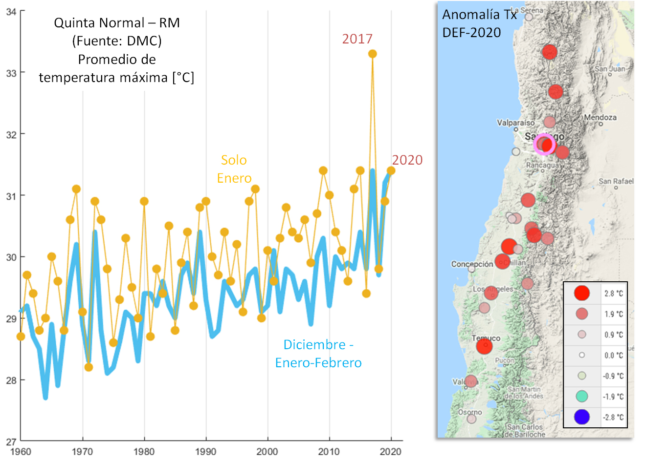 Figure 2: In the left-hand panel, the light blue line displays the average temperatures recorded in the December -February period from 1960 to 2020; the yellow line shows averages for January alone, including most notably 2017. The right-hand panel shows the maximum average temperature anomaly for the summer of 2019/2020 in relation to the climatological average (1980-2010). Source: Chile’s meteorological service (Dirección Meteorológica de Chile, DMC) and its general water directorate (Dirección General de Aguas, DGA).
In addition to the high summer temperatures, this season was preceded by an extremely dry winter, with a precipitation deficit of 50% to 80% (Garreaud 2020). Thus, as expected in December (Zamorano et al. 2019), we entered the summer of 2019/2020 with climatic conditions that were ripe for the spread of forest fires in central Chile. Although it is impossible to compare every aspect of the climate during these two summers and its impact on forest fires, our base temperature and precipitation indices suggest that the summer conditions in 2019/2020 were comparable to those in the summer of 2016/2017, when forest fires burned 570,000 hectares, an area ten times greater than the historic average (see Figure 2 and additional details in Chapter 5 of the Report to the Nation on Fires in Chile). We wish to emphasize that factors that are favourable to the spread of fires, such as the duration and intensity of heatwaves, can also explain some of the differences between the two summers. Specifically, January 2017 – when the megafires occurred – was extreme, with monthly average maximum temperatures of 33.3°C (Figure 2, orange line in the left-hand panel).
CONAF reports that some 85,000 hectares have burned to date, which is more than the historic average (not including 2016-2017), but less than was expected for this year’s warm summer (some 230,000 hectares on average, within a range of 140,000 to 350,000 hectares, according to the adjustment shown in Figure 1). This lower than expected burned area is certainly good news, but it must be seen in context. As in the case of climate indices, the total burned area is a very simplified metric for the socio-environmental and economic damage experienced during the fire season. Therefore, the territorial and vegetation distribution and the origin of this season’s fires should be studied in-depth to obtain an adequate understanding of what happened. However, the 80,000+ hectares that have burned still represent a huge area and tremendous damage, which includes the loss of more than 200 homes in the Rocuant and San Roque hills of Valparaíso. Similarly, the megafire in the Agua Fría sector, in the Andean foothills of Curicó in the Maule Region, which began in mid-February and was brought under control on 1 March, consumed more than 13,000 hectares of highly biodiverse native forest (Figure 3).
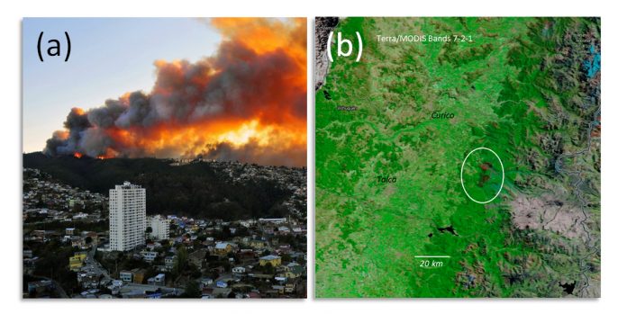 Figure 3: The photo on the left shows the fires at the rural-urban interface of Valparaíso on 24 December 2019. On the right, a TERRA satellite image taken at the end of February 2020, showing the aftermath of the 10,000+ hectares that burned in the Andean foothills of Curicó (Maule Region) in the Agua Fría fire.
The burned area for central Chile – lower than was expected given the climatic conditions that were present – could reflect certain advances in prevention and control made after the megafires of January 2017. In particular, the public and private sectors have increased their efforts to detect and control hotspots early on, investing a record amount of CLP120 billion (US$162 million) this summer. New detection technologies, increases in the number of firefighters, and improved firefighting systems also helped to combat fires in a season in which the climate has been especially aggressive. It is paradoxical, however, to hear government officials declare that the Andean foothills fire in Curicó “will be extinguished when it rains”, echoing their position during the huge fire in Cochrane, in the Aysén Region, in the summer of 2018/2019.
Allocating more funds, distributing them appropriately across the country, and increasing the efficiency of forest fire suppression are just part of the solution. There is ample international experience of this, as countries like the USA, Spain, and Australia invest much more than Chile in combatting and controlling fires and yet they continue to have megafires that cause ever-greater damage. Thus, land use planning (including managing rural-urban interface areas, diversifying the landscape, and limiting the expansion of exotic forest plantations), early warning systems, and public education are the greatest outstanding tasks that need to be addressed to prevent tragedies and advance towards a more resilient socioecological landscape in an increasingly complex climate future.
Edited by José Barraza, scientific disseminator (CR)2
References
Carlos Zamorano-Elgueta, Alejandro Miranda, Antonio Lara & René Garreaud: La crisis sociopolítica representa una potencial tragedia socioecológica en Chile. El Mostrador; 31 December 2019
González, M.E., Sapiains, R., Gómez-González, S., Garreaud, R., Miranda, A., Galleguillos, M., Jacques, M., Pauchard, A., Hoyos, J., Cordero, L., Vásquez, F., Lara, A., Aldunce, P., Delgado, V., Arriagada, Ugarte, A.M., Sepúlveda, A., Farías, L., García, R., Rondanelli, R.,J., Ponce, R.,Vargas, F., Rojas, M., Boisier, J.P., C., Carrasco, Little, C., Osses, M., Zamorano-Elgueta, C., Díaz-Hormazábal, I., Ceballos, A., Guerra, E., Moncada, M., Castillo, I . 2020. Forest fires in Chile: causes, impacts and resilience. Center for Climate and Resilience Research (CR)2, Universidad de Chile, Universidad de Concepción and Universidad Austral de Chile
González, ME., Gómez-González, S., Lara, A., Garreaud, R. & Díaz-Hormazábal, I. 2018. The 2010-2015 Megadrought and its influence on the fire regime in central and south-central Chile. Ecosphere DOI:10.1002/ecs2.2300
Urrutia- Jalabert R., González, ME., González-Reyes, A., Lara, A. & R Garreaud. 2018. Climate variability and forest fires in central and south-central Chile. Ecosphere DOI:10.1002/ecs2.2171
Garreaud, R., 2019: Estado del clima y eventos extremos el año 2019. Infografía CR2, available at: http://www.cr2.cl/wp-content/uploads/2020/01/Eventos-extremos-2019.jpg
 Secures Its Continuity")

, an Endangered Species")