

toked by a summer heat wave and strong winds, widespread fires have been raging through south-central Chile since February 2, 2023. Over the course of several days, the deadly fires have destroyed more than 1,000 homes and have spread across more than 294,000 hectares (1,100 square miles).
President Gabriel Boric issued emergency declarations for the regions of Biobío and neighboring Ñuble on February 3, the same day that the Moderate Resolution Imaging Spectroradiometer (MODIS) on NASA’s Aqua satellite acquired this image (above) of the fires. Smoke from the fires can be seen billowing from Santa Juana, south of Concepción, out to the Pacific Ocean.
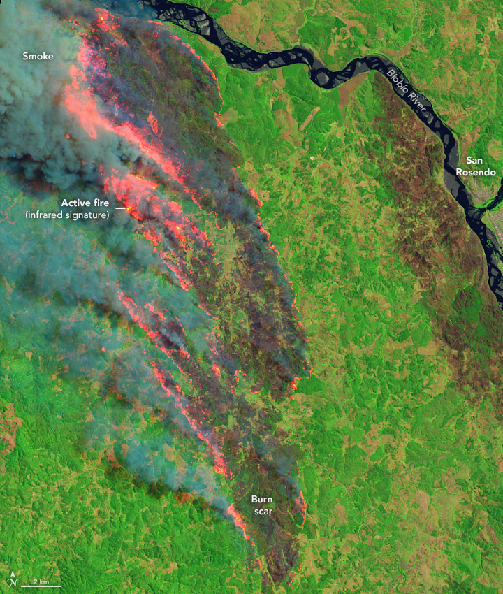 A more detailed view of the fires near Santa Juana can be seen in this false-color image acquired on the same day by the Operational Land Imager (OLI) on Landsat 8. This false-color image combines shortwave infrared, near infrared, and visible light (OLI bands 6-5-3) to make it easier to identify the unburned vegetated areas (green) and the recently burned landscapes (brown). Active fires are shown in red.
The Biobío and Araucanía regions have been the hardest hit by fires in terms of affected area, where collectively more than 200,000 hectares have burned. According to Chile’s National Forestry Corporation, the country’s total burned area so far this summer—294,000 hectares as of February 7—is seven times more than the five-year average. The worst fire on record (which goes back to 1985) was in 2017, when 570,000 hectares burned.
Air temperatures in Chile’s hard hit regions have exceeded 104 degrees Fahrenheit (40° Celsius). Meanwhile, warm easterly winds blown from Argentina down the slopes of the Andes, also known as “Puelche winds,” contributed to the rapid spread of the fires.
Chile is in the midst of a drought, which has lowered reservoirs and caused tensions over water. According to the World Meteorological Organization, the 13-year megadrought in central Chile is the longest in at least 1,000 years.
NASA Earth Observatory images by Lauren Dauphin and Allison Nussbaum, using Landsat data from the U.S. Geological Survey and MODIS data from NASA EOSDIS LANCE and GIBS/Worldview. Story by Emily Cassidy with input from René Garreaud, University of Chile.
Original publication from NASA Earth Observatory
 Secures Its Continuity")

, an Endangered Species")