

- Delimiting the rural-urban interface areas of Chile and defining those that have a higher risk of fires will allow efficient targeting of management and prevention policies.
- Using artificial intelligence models (machine learning) was determined which conditions determine a greater risk of fires, which allowed proposing an urban-rural interface for Chile.
- The proximity of cities to different agricultural and forestry production systems represents the places with the highest probability of accidents.
By Alejandro Miranda, Jaime Carrasco, Mauro González, Cristóbal Pais, Antonio Lara, Adison Altamirano, Andrés Weintraub and Alexandra D. Syphard.
The urban-rural interface is where human communities coexist with fire-prone vegetation cover. For example, houses are immediately next to a thicket or forest plantation. Worldwide, it is in this space where fires cause the greatest number of deaths and loss of homes and other buildings, so their identification and evaluation of landscape management alternatives are of utmost importance for land planning policies.
In order to define and identify the urban-rural interface areas that exist in Chile and their potential fire risk, an article published in the scientific journal Environmental Research Letters proposes the use of artificial intelligence models (machine learning) to identify the areas with the highest risk of fires and also to know the different variables that affect their occurrence. In turn, based on historical evidence, areas are proposed that should be considered urban-rural interface and whose management at the landscape scale should be aimed at minimizing the risk and spread of fire.
The area chosen to determine the functionality of this instrument was the south-central zone of the country (between the Valparaíso and Los Lagos regions), where 98% of the country’s forest fires occur, most of which are caused by people, either intentionally or negligently. In these regions, 530,000 hectares were burned in 2017, corresponding to ten times the national average (55,000 hectares per year). Along with this, in the last 50 years, this area has undergone significant changes in its vegetation cover, going from native forest to scrub, crops, grasslands, and forest plantations, among other changes. The plantations have multiplied by ten, increasing from 300,000 hectares, in 1974, to three million in 2018, with pine and eucalyptus being the predominant species, which creates highly homogeneous landscapes with a high load of highly flammable fuel.
The data on fires that occurred in the central-south zone, obtained from the National Forestry Corporation (CONAF), were modeled using artificial intelligence based on the variables with the greatest influence on fires. Thus, it was possible to predict which areas are most at risk of suffering them in the future to define where preventive policies should be focused. The data corresponds to the ignition points of each fire that occurred between January 2013 and December 2015, covering 19,413 fires that left a total burned area of 245,815 hectares. Concerning risk factors, variables related to (a) human activity, (b) geography and topography, and (c) land cover were selected.
Results
At the national level, the model showed that the most important fire risk variables (Figure 1), according to the three factors mentioned above, are: (a) human infrastructure, mainly population density and proximity of cities and roads to coverage plants, which is consistent with the fact that 99.7% of fires in Chile are of human origin; (b) the altitude and latitude, since it was appreciated that the fires are concentrated between the Maule and Biobío regions and, as they are mainly associated with human activity, they occur in the most developed areas, which correspond to the lower parts of the coastal mountain range and the intermediate depression, on the other hand, in less populated areas and with less presence of fires, there is greater coverage of native forest; and (c) regarding land cover, the model suggests that the type of vegetation influences the probability of ignition. This is because some types of vegetation cover have more dry branches and leaves, or are more flammable, which, combined with human action and geography, produces unique local effects.
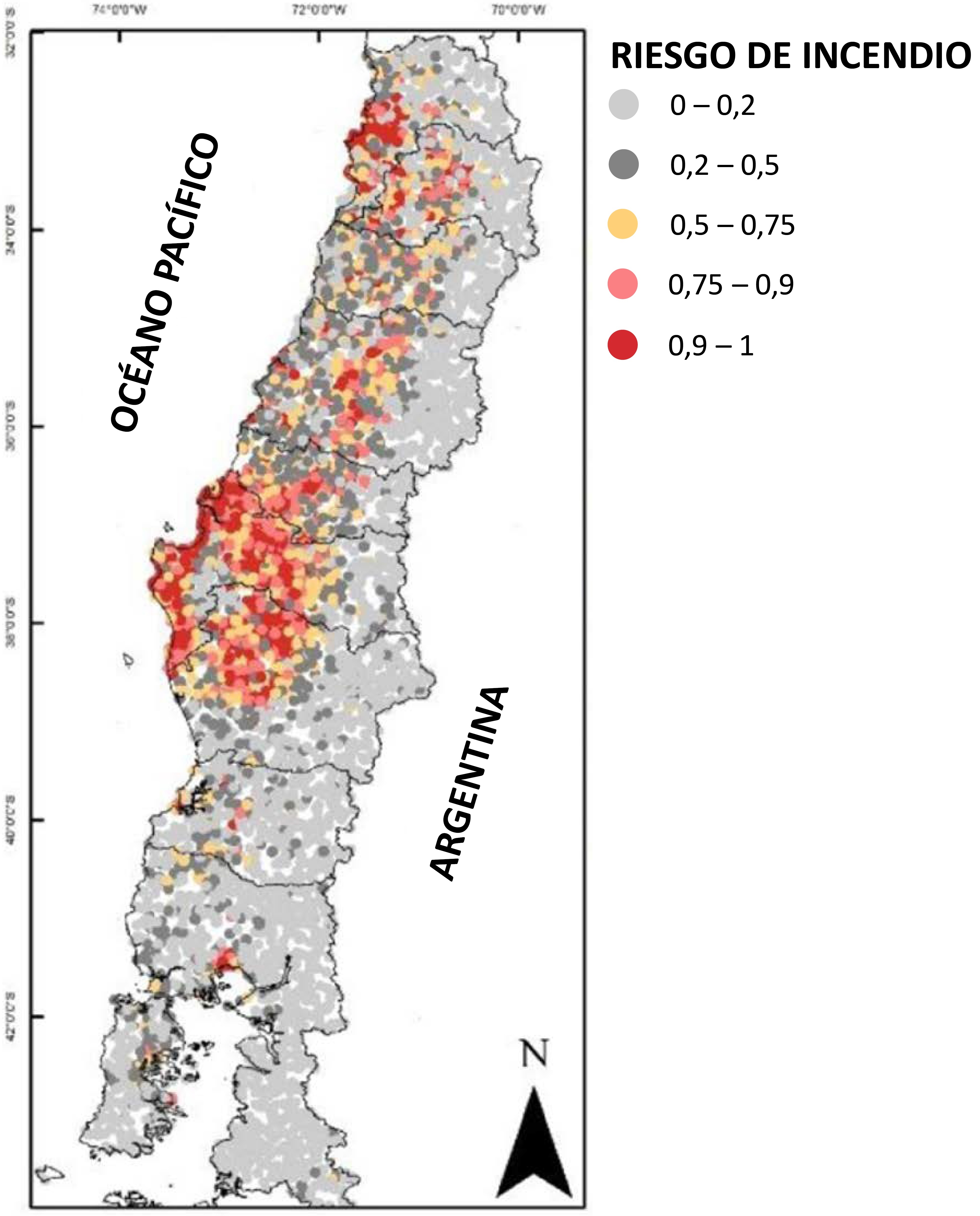 Figure 1. Fire risk prediction map at the national level. From 0 to 0.5, there is a low risk of fire occurrence; from 0.5 to 0.75, there is a medium probability, from 0.75 to 0.9, there is a medium-high risk of fire and from 0.9 to 1, is a high risk. There is a high risk in the Valparaíso area and coastal sectors and valleys of the Biobío and La Araucanía regions. Source: Modified from Miranda et al., 2020.
Likewise, the results determined risk thresholds, identifying, for example, what is the distance that must exist between a human population and a type of vegetation in order to decrease or increase the risk of fire. In this sense, at the national level, a city should be at least 1.2 kilometers away from a vegetation cover with a high fuel load to reduce the risk of forest fire since, if the distance is less, the risk increases. Likewise, regarding the type of ground cover, if the percentage of forest plantations exceeds 4.5%, the risk of fires increases; On the other hand, if the coverage is native forest, the risk increases when it exceeds 18%. These values are presented in Table 1.
Table 1. Forest fire risk thresholds at the national level and in the five areas determined in the study
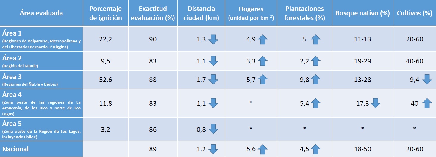 The arrows point to an increased risk of fire. For example, at the national level, a distance of fewer than 1.2 kilometers between human communities and vegetation cover increases the risk; in the case of forest plantations, if there is more than 4.5%, the risk also increases. However, each area studied has a different reality. For example, in the case of area 3, a distance of fewer than 1.7 kilometers between human communities and vegetation covers increases the risk; not so in area 5, where the risk increases at a distance of fewer than 0.8 kilometers. The asterisk (*) denotes a threshold that is not relevant. Source: Modified from Miranda et al., 2020.
Conclusion
Considering a potential increase in forest fires due to climate change and land-use change is necessary to delimit the rural-urban interface areas of Chile and define those with the highest fire risk in order to efficiently target policies prevention, management, and combat of forest fires, and, mainly, territorial planning. Furthermore, the methodological approach presented in the study allows us to understand the variables that increase risk and adapt to multiple local realities and changing scenarios through scales and times.
The research revealed that not all combinations and interactions between human infrastructure and vegetation cover are potentially dangerous but depend on the local context. For example, the approach proposed through artificial intelligence indicated that the proximity between human infrastructure and forest plantations presented a higher risk of fires than when the same proportion of coverage was the native forest. The areas of the country where there is a greater number of fires and burned areas would be explained by a combination of human action and sectors where the native forest has been replaced by homogeneous forest plantations or is highly degraded or fragmented.
In summary, this study reveals the need to define and delimit the urban-rural interface areas in Chile to prevent forest fires that put the population, infrastructure, and ecosystems at risk through policies focused on the local realities of the country.
1 Centro de Ciencia del Clima y la Resiliencia (CR)2; 2 Laboratorio de Ecología del Paisaje y Conservación, Universidad de La Frontera; 3 Departamento de Ingeniería Industrial, Universidad de Chile; 4 Instituto Sistemas Complejos de Ingeniería (ISCI); 5 Instituto de Conservación, Biodiversidad y Territorio, Universidad Austral; 6 Industrial Engineering and Operations Research Department, University of California; 7 Fundación Centro de los Bosques Nativos (FORECOS); 8 Centro Butamallin Investigación en Cambio Global, Universidad de La Frontera; 9 Sage Insurance Holdings, LLC, La Mesa, CA, United States of America.
References
Miranda, A., Carrasco, J., González, M., Pais, C., Lara, A., Altamirano, A., Weintraub, A. & Syphard, A. (2020). Evidence-based mapping of the wildland-urban interface to better identify human communities threatened by wildfires. Environ. Res. Lett. 15 094069
 Secures Its Continuity")

, an Endangered Species")