
By Gabriela Azócar, (CR)2 associate researcher; Marco Billi, (CR)2 postdoctoral researcher; and Claudia Alonso, (CR)2 research assistant.
Acknowledgments: Antonia Carrasco, Daniela Loyola, Romina Duarte
The magnitude of the damage caused by the fire in Viña del Mar at the beginning of January 2023 has once again reminded us of the relevance that these socio-environmental disasters have for a country like Chile with vast extensions of forest plantations and interface zones. The link between forest fires and the climate crisis has heightened concern about the serious consequences of this type of event. How that relationship is communicated, however, can constitute a misinformation risk. Climate change has affected the intensity and frequency of forest fires and the damage they cause (1–4). Indeed, the increase in the number of events and areas affected by forest fires that we have been able to observe in recent years has been boosted by a greater frequency of heat waves, prolonged dry cycles, and soil degradation, especially in areas with Mediterranean climates and landscapes such as the central zone and part of southern Chile (5,6).
However, although climate change favors those conditions that favor the ignition and spread of fire, it is not the direct cause of these (7-10). Experts and various investigations agree that at least 90% of forest fires have an anthropogenic origin (5,11-14), that is, their ignition is due to voluntary or involuntary practices of human beings. Even so, it is not clear in what proportion it is negligent or intentional acts, since the evidence usually disappears because of the fire itself. This hinders the police investigation of possible crimes and the consequent application of sanctions (15).
In the field of fire risk analysis and modeling, on the other hand, there is substantial progress. From scientific research, risk has been defined as the probability of occurrence of an event that can generate potential damage (16,17). This is due to a combination of three factors: a) the threat (probability and expected intensity of the fire), b) the exposure (presence of ecosystems, people, goods, or services in the area potentially affected by the fire) and c) vulnerability (predisposition to suffer serious damage or loss from the fire). In the case of forest fires, the most marked risk usually occurs in the ecological and community environments that make up the urban-forest interface zones. In these areas, a series of geographic, topographic, climatic, land cover, and social variables interact (18–21), determining the probability and magnitude of possible damage caused by fire. It is precisely the interaction between natural and social conditions that determines the probability of damage. From this it can be deduced that the risk is contextual, that is, it depends on the characteristics of the area under analysis.
Studies in this regard tend to agree on which are the variables with the greatest weight in modeling vulnerability and risk of forest fires. Among the most common natural factors we find plant species and tree height, fuel humidity, temperature, topography, and local climate (5,11,18,22,23). On the other hand, the anthropogenic variables most mentioned in the literature are land use and cover, distance from roads, distance from urban or inhabited areas, and urban infrastructure (3,13,22,24–26). Various works on modeling forest fires agree that the variables that best explain the ignition of fire are those of a human nature. Thus, for example, in the Maule Region, one of the most devastated by the 2017 megafire, a recent study indicates that such variables are the proportion of crops, and the proximity of roads and cities (15). This corroborates the idea that the origin of the fires is associated with human activities that take place in forest-urban interface areas, something that during the period of confinement due to the COVID-19 pandemic was even more evident if we consider the lower number of forest fires that occurred during that period.
Study of the risk of forest fires
The analysis of the risk of forest fires has acquired great relevance in Chile, especially after the mega-fire of 2017, during which 529,974 hectares were destroyed by fire with a balance of 3,000 homes lost and 11 people killed (27,28). Based on the concern that phenomena of such magnitude continue to occur, different models have been developed regarding the ignition of fires in different regions of the country (15,19,29). During the last wildfire season, while unfortunate, the results of these studies have been corroborated. A large part of the fires has been generated in areas indicated as high risk by these studies.
The fire in Viña del Mar in December 2022 occurred in the upper area of the city, in an area classified as high risk by a study published in 2021. As can be seen in Figure 1, the area affected by this fire assumes the highest values on the risk scale. This study indicates that in the Viña del Mar – Valparaíso conurbation, the highest level of threat has been found in the peripheral areas of the urban zone, where the presence of urban-forest interface, hills and ravines stands out, which increase the probability of ignition or propagation due to the presence of factors such as soil cover, slope, and slope exposure (30).
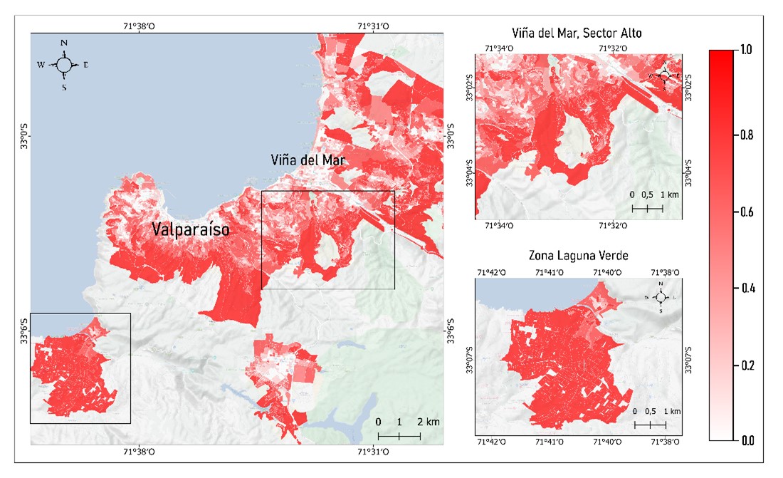
It should be noted that Viña del Mar has a higher percentage of areas with low threat than Valparaíso due to its higher rates of urbanization. However, it has large areas of urban-forest interface that contribute to increasing the threat facing the territory.
Valparaíso, on the other hand, due to its topography, presents a medium or high fire threat in most of its territory, especially around the Amphitheater and in Laguna Verde where forest plantations abound (see figure 1) (30). This translates into a high degree of awareness on the part of the population about the risk of fires in interface zones, as well as the commitment of the municipality to address this problem through its Master Plan for Risk Management. A series of barriers, however, stand in the way of implementing this type of measure: problems with garbage management, deficient territorial planning, high levels of marginalization and crime, insufficient municipal resources, among others (31).
It should be noted that the demographic density patterns presented by both communes generate a high level of heterogeneity in the distribution of the population and housing; Despite this, it is common to find densely populated areas on the slopes and hills of the peripheries, which are high-threat areas, as previously indicated. These areas are often the most vulnerable, due to the concentration of conditions of poverty and social marginalization, less infrastructure, as well as a high degree of irregularity in the location and quality of housing. These areas are also often the ones with the least response capacity due to less access to capital and emergency services (30).
Wildfire Governance: Different Narratives on Risk
Having scientific knowledge about the causes and factors associated with forest fires does not seem to be enough if it is not adequately transferred to decision makers and political and technical organizations in charge of implementing prevention, preparation, and combat actions. In this regard, it is necessary to generate instances of dialogue between the different agents involved in the governance of fires, even more so when, from each of their positions, the risk acquires different meanings. For the scientific sphere, risk is understood as a probability of damage that can be calculated and projected, while technical and political actors see it as a social problem associated with a low level of commitment of communities and people with prevention. On the other hand, for communities, the risk is associated with being prepared for the occurrence of a fire, that is, knowing what to do to protect themselves from its damage. This is not entirely strange if we consider that part of the prevention campaigns is focused on teaching how to react to a forest fire that is already occurring.
The narratives on risk sustained by the different agents of the governance of forest fires lead to a series of controversies about who or what is identified as responsible for the management of this type of disaster and how it should be addressed. In this context, the governance of forest fires tends to fragment into disjointed actions, of a reactive nature, with limited and unequal coverage in different territories (32).
A clear example of this is what is happening in the Maule Region. The analysis of the formal links between agents of the governance of forest fires in this region shows how it is organized into three groups of agents (see figure 2).
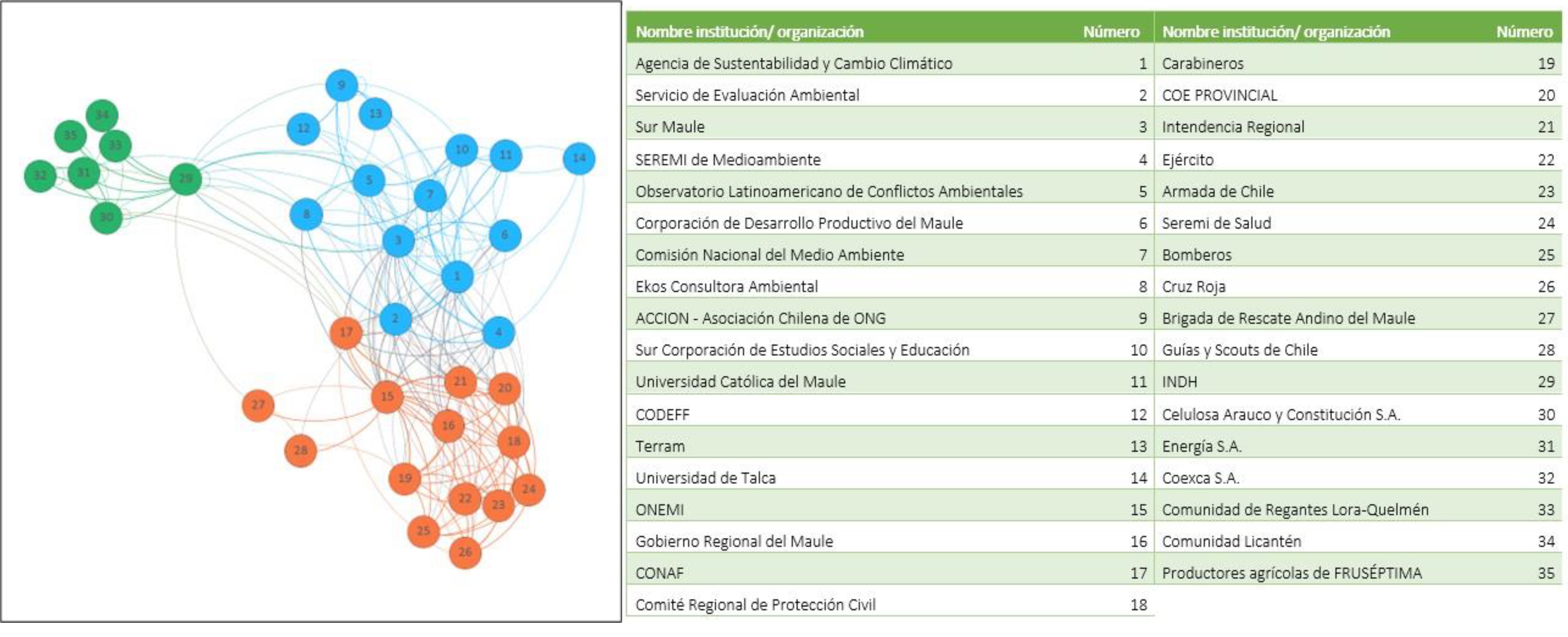
The orange group is made up, mainly, of public institutions in charge of prevention, combat and mitigation actions of the damages generated by forest fires. It is a highly interconnected group, something that reflects the good level of coordination that exists in the region regarding firefighting. The centrality of ONEMI (currently SENAPRED) stands out in this group, the institution with the highest degree of links with the agents of its group and with the network. For its part, CONAF plays an important connection role with the rest of the institutions in this group.
The light blue group is made up of organizations related to the production of information and technical and scientific knowledge on forest fires. Here, the Sustainability and Climate Change Agency is the actor that generates the greatest internal links and is the one that is most linked to the rest of the network.
The green group is made up of social organizations, public and private institutions of various kinds. This group represents the community agency within the governance of forest fires. There are no central actors within it and, compared to the other groups, it is less interconnected both internally and with the rest of the network.
The groups of agents within this governance network of the Maule Region represent three narratives on how the risk of forest fires is addressed, each one linked to a different meaning and way of acting around these disasters. The governance network depicted in this figure shows a high level of interconnection between the agents associated with risk management and the production of knowledge about forest fires, groups that are also internally highly connected. On the other hand, the link between these groups and community agents is weak. A better and greater integration of this type of agency is one of the main challenges that must be addressed to strengthen the governance of forest fires.
Recommendations
Promote the use of scientific information generated around the risk of forest fires in technical and political organizations in charge of disaster management. This implies generating more and more detailed information, which makes it possible to effectively guide the decisions to be made at local scales. The transparency and dissemination of this information must be taken care of to promote the understanding, preparation, and response capacity of local actors.
Clearly differentiate prevention from preparedness as part of wildfire risk management. Prevention must be worked from a proactive and long-term approach that considers the consequences that climate change and drought trends will have on the increased risk of forest fires. Strategies specifically aimed at reducing vulnerability and increasing resilience should also be included. Regarding preparation, the training of people and communities must be strengthened in how to prevent fires from occurring, promoting the controlled use of fire, reporting negligent actions and behaviors that care for the environment.
Adapt prevention strategies to the characteristics of the territories and interface zones, so that the knowledge delivered is adjusted to the reality of these social and ecological environments, thereby acquiring greater meaning and value for those who are recipients of this information.
Generate instances of dialogue of a transdisciplinary nature in which political, technical, scientific and community agents discuss their ways of understanding risk and how to manage it, taking care of inclusiveness and equity in the incorporation of these different forms of knowledge. In addition, it is recommended to create an institutional framework that fosters the interface between scientific knowledge, society, and decision-making at different scales.
References
- Matt Jolly W, Freeborn PH, Page WG, Butler BW. Severe fire danger index: A forecastable metric to inform firefighter and community wildfire risk management. Fire. 2019;2(3):1–24.
- Jolly WM, Cochrane MA, Freeborn PH, Holden ZA, Brown TJ, Williamson GJ, et al. Climate-induced variations in global wildfire danger from 1979 to 2013. 2015; Available from: www.nature.com/naturecommunications
- Caggiano MD, Hawbaker TJ, Gannon BM, Hoffman CM. Building loss in wui disasters: Evaluating the core components of the wildland–urban interface definition. Fire. 2020;3(4):1–17.
- Flannigan M, Stocks B, Turetsky M, Wotton M. Impacts of climate change on fire activity and fire management in the circumboreal forest. Glob Chang Biol [Internet]. 2009 Mar 1 [cited 2022 Aug 1];15(3):549–60. Available from: https://doi.org/10.1111/j.1365-2486.2008.01660.x
- Kang Y, Jang E, Im J, Kwon C, Kim S. Developing a new hourly forest fire risk index based on catboost in South Korea. Applied Sciences (Switzerland). 2020;10(22):1–21.
- Meneses BM. Vegetation recovery patterns in burned areas assessed with landsat 8 oli imagery and environmental biophysical data. Fire. 2021;4(4).
- Westerling AL, Hidalgo HG, Cayan DR, Swetnam TW. Warming and earlier spring increase Western U.S. forest wildfire activity. Science (1979) [Internet]. 2006 Aug 18 [cited 2022 Jul 20];313(5789):940–3. Available from: https://doi.org/10.1126/science.1128834
- Masson-Delmotte V, Zhai P, Pörtner HO, Roberts D, Skea J, Calvo E, et al. El cambio climático y la tierra Resumen para responsables de políticas Editado por [Internet]. 2020. Available from: www.ipcc.ch
- Parisien MA, Parks SA, Krawchuk MA, Little JM, Flannigan MD, Gowman LM, et al. An analysis of controls on fire activity in boreal Canada: comparing models built with different temporal resolutions. Ecological Applications [Internet]. 2014 Sep 1 [cited 2022 Aug 1];24(6):1341–56. Available from: https://doi.org/10.1890/13-1477.1
- Bowman DMJS, Williamson GJ. River flows are a reliable index of forest fire risk in the temperate tasmanian wilderness world heritage area, Australia. Fire. 2021;4(2).
- Maniatis Y, Doganis A, Chatzigeorgiadis M. Fire Risk Probability Mapping Using Machine Learning Tools and Multi-Criteria Decision Analysis in the GIS Environment: A Case Study in the National Park Forest Dadia-Lefkimi-Soufli, Greece. Applied Sciences. 2022;12(6):2938.
- Ganteaume A, Camia A, Jappiot M, San-Miguel-Ayanz J, Long-Fournel M, Lampin C. A Review of the Main Driving Factors of Forest Fire Ignition Over Europe. Environ Manage. 2013;51:651–62.
- Ricotta C, Bajocco S, Guglietta D, Conedera M. Assessing the influence of roads on fire ignition: Does land cover matter? Fire. 2018;1(2):1–9.
- Xofis P, Konstantinidis P, Papadopoulos I, Tsiourlis G. Integrating remote sensing methods and fire simulation models to estimate fire hazard in a south-east mediterranean protected area. Fire. 2020;3(3):1–23.
- Azócar G, Alfaro G, Alonso C, Calvo R, Orellana P. Modeling the Ignition Risk: Analysis before and after Megafire on Maule Region, Chile. Applied Sciences (Switzerland). 2022 Sep 1;12(18).
- Scheer D, Benighaus C, Benighaus L, Renn O, Gold S, Röder B, et al. The Distinction Between Risk and Hazard: Understanding and Use in Stakeholder Communication. Risk Analysis. 2014;34(7):1270–85.
- Dong X, Shao G, Limin D, Zhanqing H, Lei T, Hui W. Mapping forest fire risk zones with spatial data and principal component analysis. Science in China: Series E Technological Sciences [Internet]. 2006;49:140–9. Available from: www.scichina.com
- van Hoang T, Chou TY, Fang YM, Nguyen NT, Nguyen QH, Canh PX, et al. Mapping forest fire risk and development of early warning system for NW vietnam using AHP and MCA/GIS methods. Applied Sciences (Switzerland). 2020;10(12):1–19.
- Miranda A, Carrasco J, González M, Pais C, Lara A, Altamirano A, et al. Evidence-based mapping of the wildland-urban interface to better identify human communities threatened by wildfires. Environmental Research Letters. 2020 Sep 1;15(9).
- Chuvieco E, Aguado I, Yebra M, Nieto H, Salas J, Martín MP, et al. Development of a framework for fire risk assessment using remote sensing and geographic information system technologies. Ecol Modell. 2010 Jan 10;221(1):46–58.
- Aragoneses E, Chuvieco E. Generation and mapping of fuel types for fire risk assessment. Fire. 2021;4(3).
- Martin J, Hillen T. The spotting distribution of wild fires. Applied Sciences (Switzerland). 2016;6(6).
- Pérez-Sánchez J, Jimeno-Sáez P, Senent-Aparicio J, Díaz-Palmero JM, Cabezas-Cerezo J de D. Evolution of burned area in forest fires under climate change conditions in southern Spain using ANN. Applied Sciences (Switzerland). 2019;9(19).
- Ghorbanzadeh O, Blaschke T, Gholamnia K, Aryal J. Forest fire susceptibility and risk mapping using social/infrastructural vulnerability and environmental variables. Fire. 2019;2(3):1–27.
- Montiel-Molina C, Vilar L, Romão-Sequeira C, Karlsson O, Galiana-Martín L, de Lomana GMG, et al. Have historical land use/land cover changes triggered a fire regime shift in central Spain? Fire. 2019;2(3):1–28.
- Minsavage-davis CD. Evaluating the Performance of Fire Rate of Spread Models in Northern-European Calluna vulgaris Heathlands. 2022;
- de la Barrera F, Barraza F, Favier P, Ruiz V, Quense J. Megafires in Chile 2017: Monitoring multiscale environmental impacts of burned ecosystems. Science of the Total Environment. 2018 Oct 1;637–638:1526–36.
- Bowman DMJS, Moreira-Muñ Oz A, Kolden CA, Chávez RO, Muñoz AA, Salinas F, et al. Human-environmental drivers and impacts of the globally extreme 2017 Chilean fires. Tapuya: Latin American Science, Technology and Society [Internet]. 2021;4(1). Available from: https://doi.org/10.1007/s13280-018-1084-1
- Miranda A, Mentler R, Moletto-Lobos Í, Alfaro G, Aliaga L, Balbontín D, et al. The Landscape Fire Scars Database: mapping historical burned area and fire severity in Chile Earth System Science Data Discussions. Earth System Science Data Discussions [Internet]. 2022;1–22. Available from: https://doi.org/10.5194/essd-2021-467
- Amigo C, Álamos N, Arrieta D, Billi M, Contreras M, Larraguibel C, et al. Riesgo integrado de Asentamientos Humanos. Conurbación Valparaíso – Viña del Mar [Internet]. Santiago; 2020 [cited 2023 Jan 18]. Available from: https://www.cr2.cl/wp-content/uploads/2021/09/Amigo-et-al-2021-An%C3%A1lisis-de-riesgo-integrado-de-asentamientos-humanos-en-la-connurbaci%C3%B3n-de-Vi%C3%B1a-del-Mar-y-Valpara%C3%ADso.pdf
- Sapiains R, Aldunce P, Ugarte A, Marchant G, Inostroza V, Romero J. Trabajando juntos por Placeres Alto: Prevención comunitaria de incendios forestales. Santiago; 2019.
- Billi M, Moraga P, Aliste E, Maillet A, O’Ryan R, Sapiains R, et al. Informe_a_las_Naciones_Gobernanza_de_los_Elementos [Internet]. Santiago; 2021 [cited 2023 Jan 18]. Available from: https://www.cr2.cl/gobernanza-elementos
 Secures Its Continuity")

, an Endangered Species")