

René Garreaud, Deputy Director, Center for Climate and Resilience Research (CR)2
A large part of the Chilean Altiplano (the mountainous zone in the Chilean regions of Arica and Parinacota, Tarapacá, and Antofagasta, situated at altitudes greater than 3500 m.a.s.l.) received close to 100 mm of rainfall in January 2020 (see attached map). To put this number into context, let’s remember that the Chilean capital of Santiago received a total of 80 mm of rain in the whole of 2019 (although it receives 310 mm in a normal year). This Altiplano rainfall was concentrated in the second half of the month, with daily values occasionally surpassing 40 mm, and it fell most heavily in the afternoon and evening at rates that sometimes exceeded 10 mm/hour. Altiplano rainstorms are accompanied by lightning storms and hail and can cause flash flooding of waterways and even mudslides, with their attendant social and environmental impacts.
Map showing cumulative precipitation for January 2020 at South American Altiplano monitoring stations.
For most of us who are accustomed to a more moderate rainfall regime, the rainstorms of the Altiplano qualify as torrential, and curiously, they occur in an especially arid part of Chile, right in the middle of summer.
Let’s look at how this is even possible.
We begin by zooming out, as the situation in the mountains of Chile’s far north is part of the “Altiplano winter,” also known as the “Bolivian winter,” which in turn is linked to the South American monsoon, a series of convective storms (with rising air masses and intense but localized precipitation) that develop from December to March over much of the tropical and subtropical zone of the continent (Vera et al. 2006). The basic ingredients of this monsoon are high humidity that enters the continent from the Atlantic Ocean and intense surface warming. The monsoon that occurs over the centre of South America also causes the expansion of the air column and anticyclonic (counter-clockwise) circulation in the high troposphere (8-12 km above the earth) – a phenomenon known as the “Bolivian High.”
The warming of the central Andes (15°S-25°S) in the afternoons produces valley-mountain breezes on both sides of the range (see conceptual diagram). The breeze that originates in the lowlands to the east of the Andes transports moisture-laden air, while the breeze on the western slopes (facing the Pacific) transports – usually – very dry air from the deserts of Chile and Peru. For most of the year (April-November), high-altitude winds blow over the central Andes from the Pacific towards the east, favouring the development of the easterly breezes and causing the extremely dry air of the Altiplano, giving rise to a long dry season (conceptual diagram, panel A). But in the summer months, the Bolivian High produces winds from the east (from the interior of the continent towards the Pacific) over the central Andes, favouring breezes on the eastern side, which allow much more humid air to reach the Altiplano (Garreaud 1999, conceptual diagram, panel B).
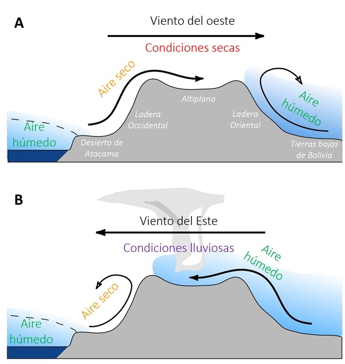 Conceptual diagram: West-east cross section through the central Andes (15-23ºS), indicating atmospheric circulation under dry conditions (winter, El Niño years) and damp conditions (summer, El Niño years)
Breezes from the east do not blow here all summer, only during a dozen or so days when the Bolivian High is most active; but when that occurs, we have all the essential ingredients for intense convective storms, with surface warming and humidity. The complex topography of the area helps to organize the convection in the highest parts of the region. This was the situation that prevailed in the second week of January this year, giving rise to the heavy cumulative rainfall we mentioned at the beginning of this note. At the time of writing (31 January 2020), precipitation had tapered off in the Altiplano (although storms have still been occurring further south, mainly over the mountains in the Atacama and Coquimbo regions); it is still quite possible, however, that convective activity will pick up again before the end of summer.
In addition to differences in the summer season, every winter is also different, alternating between very wet and rainy (such as in 2019) and very dry (as in 2015). Interannual precipitation variability in the region is essentially a function of changes in the available water vapour over the Altiplano (Garreaud & Aceituno 2000). However, until very recently, we believed these changes in humidity were determined by the intensity of the zonal flow (east-west) over the Altiplano (Garreaud & Aceituno 2001). As we have already explained, for days with precipitation, years with more prevailing easterly winds – which tend to occur during La Niña conditions – favour precipitation in the Altiplano. In contrast, in years where westerlies are more prevalent – which tends to happen with El Niño – precipitation in the Altiplano is reduced.
In the past two decades we have detected a trend of increasing precipitation over the Altiplano, with no notable increase in easterly winds over the central Andes (La Niña years); this has been attributed to a marked increase in moisture above the Amazon basin (Segura et al. 2020) and has forced us to rethink how water vapour actually reaches the Altiplano. Another novel finding emerged last summer (and part of this one), as the convective storms have not been limited to the highest parts of the mountains, but have been observed above the pre-Altiplano on the western slopes of the Andes, and even in the Atacama Desert (Garreaud 2019). This could be associated with an increase in available humidity from the Pacific, a source of moisture that we did not consider relevant before.
References
Garreaud, R. D., 1999a: A multi-scale analysis of the summertime precipitation over the central Andes. Mon. Wea. Rev., 127, 901-921.
Garreaud, R. D., 2000: Intraseasonal variability of moisture and rainfall over the South American Altiplano. Mon. Wea. Rev., 128, 3337-3346
Garreaud, R. D., and P. Aceituno, 2001: Interannual rainfall variability over the South American Altiplano. J. of Climate, 14, 2779-2789.
Garreaud, R., 2019: Luego de la tormenta…vienen las flores. CR2 Analysis available at: http://dgf.uchile.cl/rene/DIV/Luego%20de%20la%20tormenta.pdf
Segura, H., J.C. Espinoza, C. Junquas, T. Lebel, M. Vuille, R. Garreaud, 2020: Recent changes in the precipitation‑driving processes over the southern tropical Andes/western Amazon. Climate Dynamics. https://doi.org/10.1007/s00382-020-05132-6
Vera, C., W. Higgins, J. Amador, T. Ambrizzi, R. Garreaud, D. Gochis, D. Gutzler, D. Lettenmaier, J. Marengo, C. Mechoso, J. Nogues-Paegle, P.L. Silva Diaz and C. Zhang, 2006: Towards a unified view of the American Monsoon System. J. of Climate, 19, 4977-5000.
 Secures Its Continuity")

, an Endangered Species")