
Improving carbon baseline estimations with high-resolution remote sensing analyses.
Panama has decided to put Nature-based Solutions at the core of its climate strategy, with Blue Carbon playing a prominent role in its current climate ambition. As such, the conservation and restoration of mangroves are among Panama’s primary objectives to achieve its climate goals. However, the significance of Panama’s mangroves extends beyond their contribution to the local climate goal. Despite Panama’s relatively small size, its location as a bridge between North and South America makes it a biodiversity hotspot with particular importance for migratory birds throughout the Americas. Thus, gaining knowledge of the ecosystems where birds inhabit, including mangroves, is crucial.
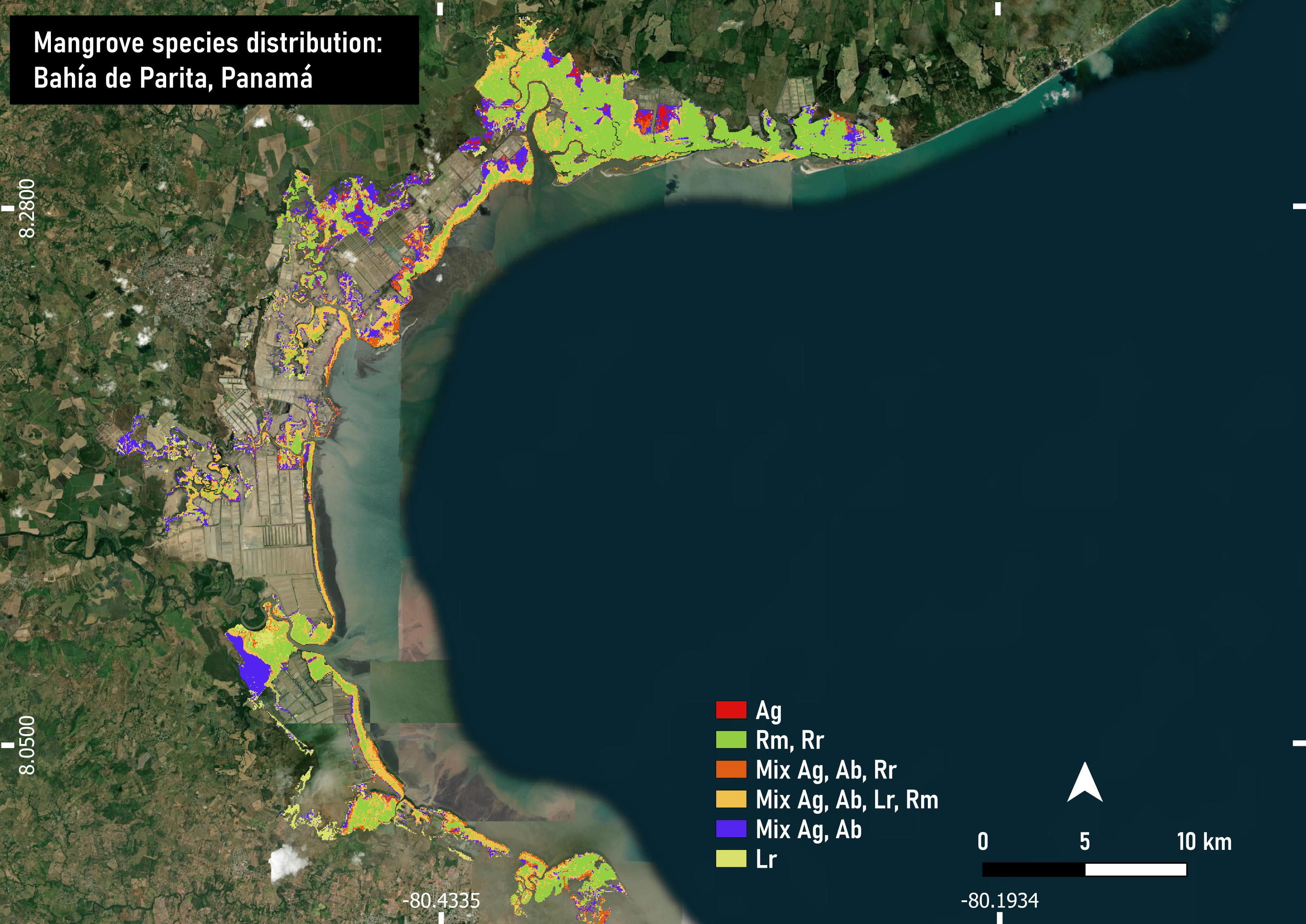
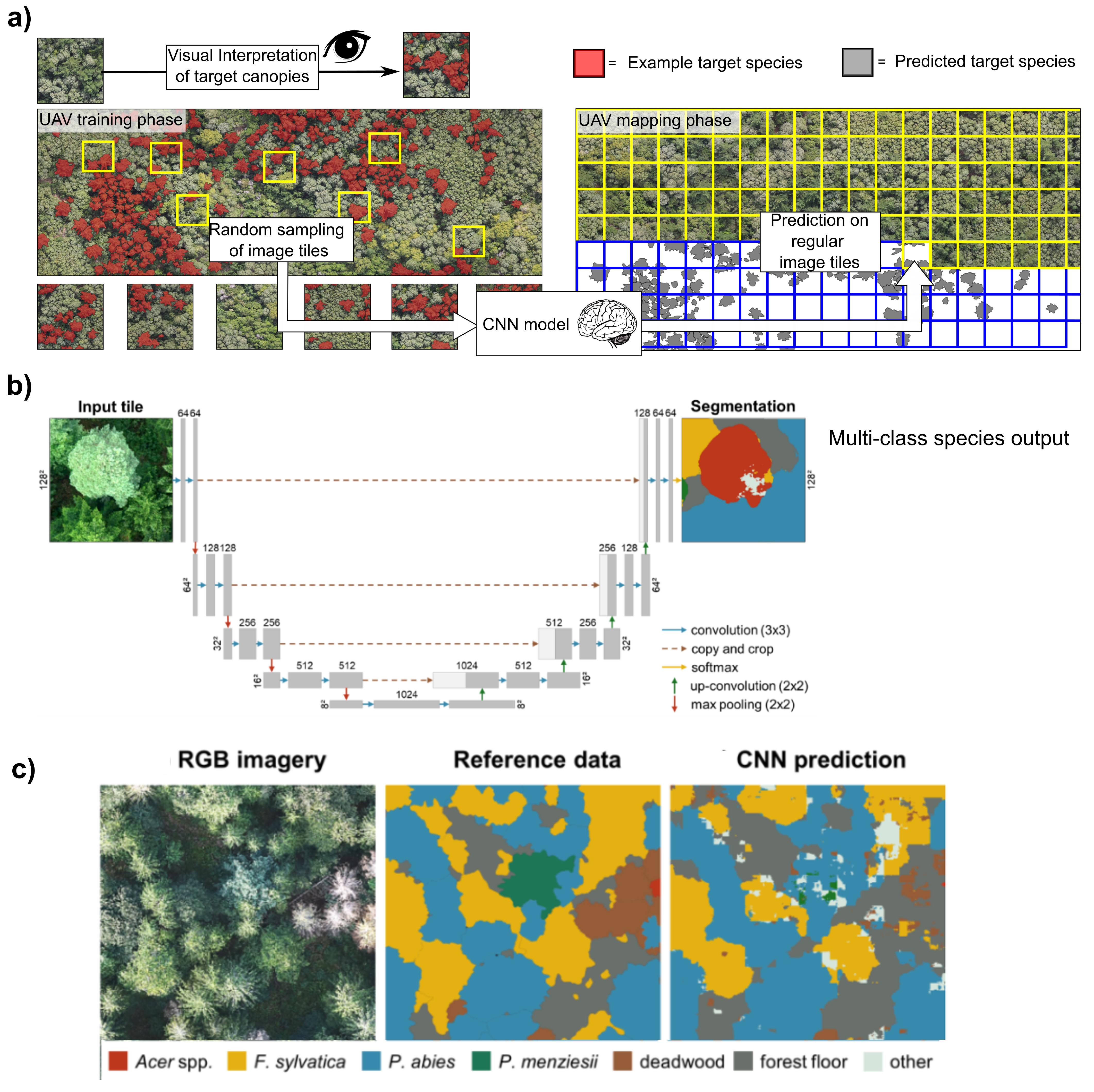
Estimating the carbon baseline is one of the first steps towards carbon-focused management, conservation, and restoration of mangroves. To develop the most detailed carbon baseline possible to support Panama’s climate ambition adequately, we have been conducting a collaborative effort to map the spatial distribution of different mangrove communities in the Bay of Parita and the Bay of Panama over the past year (e.g., Fig. 1) through the Blue Natural Heritage project. Our experimental approaches include traditional supervised classification parallel to cutting-edge alternatives for high spatial resolution remote sensing analyses, such as semantic segmentation using convolutional neural networks (CNN). The later approach comprises the photo interpretation of high-spatial-resolution images to delineate canopies of the target mangrove species (Figure 2a). These masks are used as references to train a CNN algorithm, like U-Net or DenseNet (Figure 2b). The results are supervised segmentations with a multi-class classification output (Figure 2c). These methods are revolutionary as they learn from the images’ reflectance values, texture, and context.
© Audubon Americas
© Audubon Americas
The collaboration includes the participation of researchers from the Environmental Biogeochemistry Laboratory (UMAG, Chile), Universidad de la Frontera (Chile), Center for Climate and Resilience Research (CR2, Chile), Universidad Adolfo Ibáñez (Chile), Data Observatory Foundation (Chile), McGill University (Canadá), as well as local GIS and mangrove specialist collaborating with Audubon Americas. Funding for this work included ANID Fondecyt Iniciación 1120024 and BID-UK Blue Carbon Fund PN-T1233 executed by the National Audubon Society.
Our preliminary results suggest well-defined species distribution patterns with distinct carbon stocks across the Bay of Parita (Ag, Avicennia germinans; Rm, Rhizophora mangle; Rr, Rhizophora racemosa; Ab, Avicennia bicolor; Lr, Laguncularia racemosa). These analyses were conducted by Victor Hinojosa1,2, Juliana Chavarria3, José Miguel Guevara3, Alejandro Miranda1,4,5, Javier Lopatin4,6,7, María Alejandra Bravo6, and Jorge Hoyos-Santillan1,3,4. Our results, together with NASA GEDI data, Planet Satellite Imagery, and field data will contribute to improve the current estimations of aboveground and belowground carbon stocks in Panama’s mangroves. The scope of this study could readily extend to a national level (~ 178,000 ha) based on the several existing maps of mangrove cover in Panama.
Por: Jorge Hoyos-Santillan (PhD)
Associate Researcher, University of Magallanes, Chile; Associate Professor, University of Nottingham, UK; Blue Carbon Specialist, Audubon Americas, US. | Leer publicación en Mangrove Alliance (publicación en inglés)